Saturday, May 16, 2026Vol. III · No. 136Subscribe
The Mining, Energy & Technology Wire
Mining · Analysis

Satellites Reshape Energy Exploration

From hyperspectral imaging slashing mineral discovery costs by 80% to InSAR monitoring millimeter-scale ground shifts at oil fields, space-based earth observation is transforming how energy companies find resources and manage infrastructure.

Satellites Reshape Energy Exploration
PhotographFrom hyperspectral imaging slashing mineral discovery costs by 80% to InSAR monitoring millimeter-scale ground shifts at oil fields, space-based earth observation is transforming how energy companies find resources and manage infrastructure.

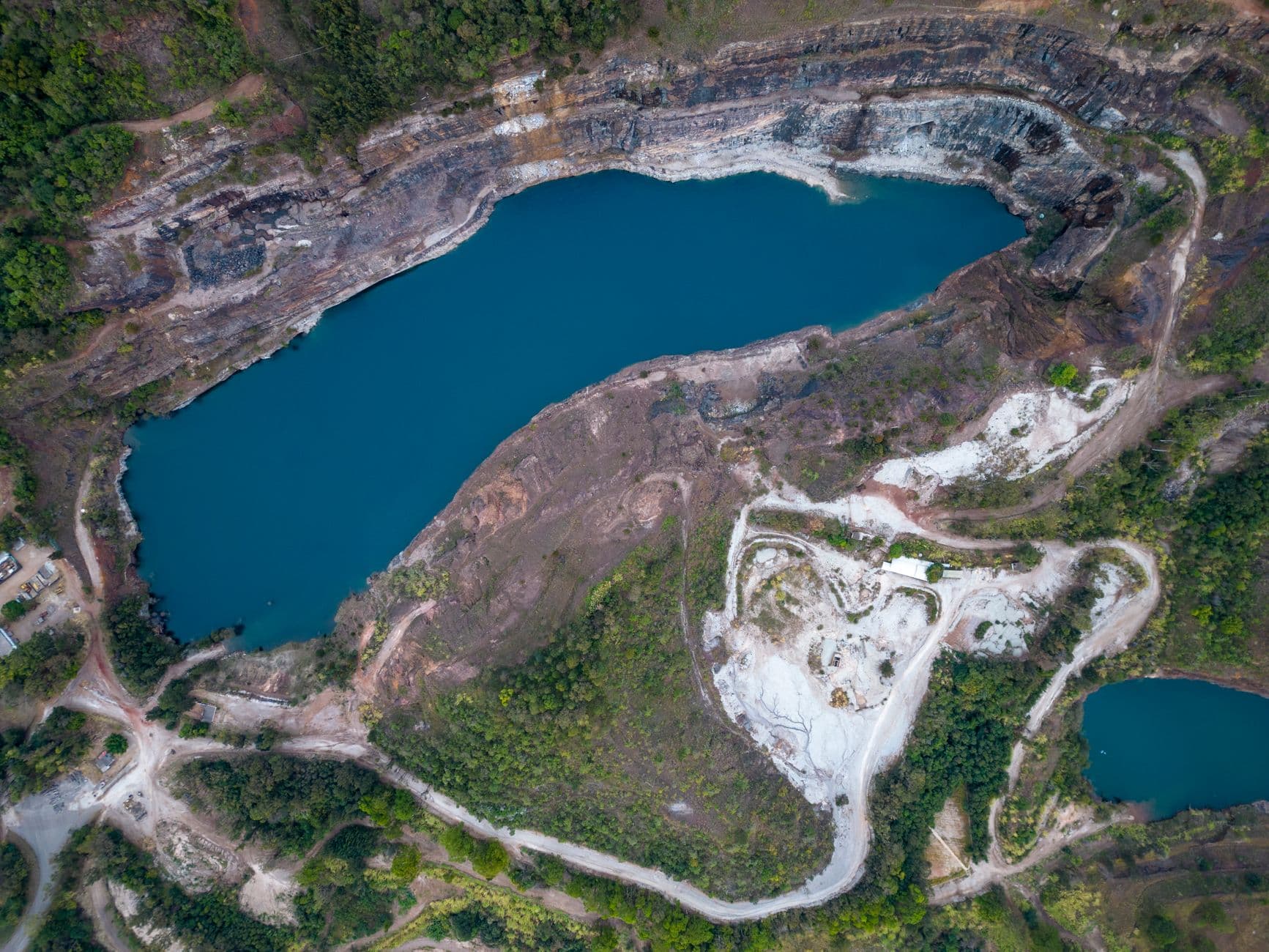
Mining companies are screening vast areas for mineral potential in days, slashing traditional discovery timelines and costs by up to 80–85% , according to Farmonaut, a platform deploying hyperspectral satellite imagery for mineral exploration. The technology analyzes electromagnetic energy reflected from Earth's surface to identify distinct spectral signatures for minerals ranging from lithium to rare earths—even when hidden beneath thin vegetation or soil cover.

Unlike conventional multispectral sensors that capture a handful of broad bands, hyperspectral satellites record hundreds of narrow, contiguous spectral bands spanning from the visible to the shortwave infrared, extracting detailed chemical and physical information from land, crops, forests, and mining prospects , the company reported in March 2026.

The shift comes as the global satellite-based earth observation market is forecast to grow from $3.5 billion in 2022 to $6.4 billion by 2032, driven by rising demand for high-resolution imagery and expanding government investment in space-based data programs, with a compound annual growth rate of 6.6% , according to Allied Market Research analysis published May 6.

Can Satellites Really Replace Boots on the Ground?

For European mining operations, the answer is increasingly yes. As part of EUSPA Pilot projects, Norwegian exploration company Kuniko partnered with Poland-based EO analytics startup TerraEye to develop a remote sensing solution for prioritizing exploration targets using Copernicus Sentinel-2 imagery , according to the EU Agency for the Space Programme. Norway's harsh winters allow only a short seasonal window for on-site work, and each field campaign comes with high financial costs and potential risks , making satellite data particularly valuable.

The technology extends beyond exploration. French mining group Eramet, the largest producer of high-grade manganese ore worldwide, collaborated with Italian remote sensing specialist Tre Altamira to improve space-based subsidence monitoring at active and legacy sites using Copernicus Sentinel-1 radar data and advanced InSAR techniques , the EUSPA reported.

InSAR—Interferometric Synthetic Aperture Radar—has become the workhorse for monitoring ground deformation at energy infrastructure. Interferometric synthetic aperture radar measurements have been used to measure ground deformation associated with fluid injection and production at an enhanced oil recovery field in Scurry County, West Texas, where 100 million tons of supercritical CO2 have been sequestered since 1972, with InSAR data showing surface uplift up to 10 cm between January 2007 and March 2011 , according to research published in the International Journal of Greenhouse Gas Control.

Atlas InSAR provides millimetric precision of up to 1 mm/year and 2-3 mm precision on single measurement points through satellite monitoring, delivering millions of measurement points in areas of interest , according to Sixense, a geotechnical monitoring firm. The technology monitors ground deformation linked to extraction, injection, or storage activities in oil and gas operations, ensuring pipeline stability and supporting compliance with HSE requirements .

What's Driving the Space Data Boom?

Government procurement is accelerating commercial adoption. In October 2023, NASA significantly expanded its Commercial Smallsat Data Acquisition Program, awarding contracts to seven companies for earth observation data and services with a maximum combined value of $476 million over five years, with Spire Global receiving a $6.5 million 12-month CSDA contract renewal in August 2023 , according to market analysis from Exterra.

The U.S. Space Force is investing in next-generation capabilities. Rice University signed an $8.1 million cooperative agreement to lead the United States Space Force Strategic Technology Institute 4, called the Center for Advanced Space Sensing Technologies, which will bring new technologies to advance remote sensing and sensemaking from space , the university announced in March 2026.

Commercial constellations are scaling rapidly. Polish space company Eycore launched Eycore-1, an Earth observation satellite equipped with synthetic aperture radar technology, on May 3 from Vandenberg Space Force Base, making Eycore the second privately-owned business in Europe to own its own SAR satellite , SpaceNews reported. Eycore is advancing plans to invest around 50 million złoty ($14 million) to expand manufacturing capacities, with some funds used to finance construction of a new production facility for satellite radar technologies in Poland .

Meanwhile, China's Landspace Zhuque-2E Y5 carrier rocket blasted off at 11:00 am Beijing time on May 14, 2026, delivering a 2.8-ton test payload into a 900 km orbit, paving the way for satellite constellation networking , according to Friends of NASA.

How Does This Technology Actually Work in the Field?

The integration of space data with ground operations is becoming seamless. BP has adopted LiDAR scanner data processing to optimize infrastructure maintenance, reduce costs, and improve safety, using Cintoo's intuitive tool sets to verify equipment replacements remotely and save $10,000 on an in-line replacement for a flow meter by verifying dimensions of existing equipment , according to Cintoo, a point cloud processing platform.

LiDAR data is increasingly being integrated with broader asset systems including GIS platforms, inspection tools, and maintenance databases, creating a unified view of infrastructure that supports proactive management, with AI models learning from examples and automatically classifying points with remarkable accuracy , according to Latitude Media.

For mineral exploration specifically, Data and images that once required months of interpretation by specialized experts can now be analyzed in seconds, with a new generation of AI-driven systems trained on geological and environmental data ingesting spectral signatures of minerals, vegetation, and soils to identify areas of interest in seconds, with AI agents now allowing anyone to load a hyperspectral image, ask questions in plain language, and receive domain-expert answers on demand , according to the Canadian Mining Journal in February 2026.

The European Space Agency is expanding its earth observation fleet. ESA plans 65 satellite launches and other missions throughout 2026, a roughly 30% jump from last year's record figure, with the increase largely driven by a hike in Earth-observation activities including 48 satellites , Aviation Week reported in January.

However, operational challenges persist. A fire incident occurred on May 7, 2026 at a data centre in the Netherlands, impacting the Sentinel-2A and Sentinel-2C production service infrastructure, with data production and publication unavailable since 08:30 UTC , according to the Copernicus Data Space Ecosystem. The incident underscores the infrastructure dependencies behind seemingly seamless satellite data delivery.

What Changed This Week

The convergence of hyperspectral imaging, InSAR monitoring, and AI-driven analysis is fundamentally altering how energy companies discover and manage resources. Mining exploration that once required months of field campaigns can now be completed in days from orbit, while millimeter-precision ground deformation monitoring protects critical oil and gas infrastructure without site visits. Government procurement programs totaling hundreds of millions of dollars are accelerating commercial earth observation capabilities, even as operational incidents like the Netherlands data center fire remind the industry that space-based systems still depend on terrestrial infrastructure. The technology is no longer experimental—it's becoming operational standard practice across energy and mining sectors.

What to Watch

Initial access to Sentinel-1D data will be available on the Copernicus Data Access starting from Friday, April 17, with a period of overlapping operations planned from mid-April 2026 to the end of June 2026, and open access to Sentinel-1D data effective starting on April 17, 2026 , according to the Copernicus collaborative data handling system. Satellogic's Merlin constellation launches from October 2026, expanding Aleph Observer from thousands to millions of monitored sites with daily one-meter global coverage , the company announced in March. NASA's two newly selected Earth System Explorers missions will advance to the next phase of development, with each mission subject to confirmation review in 2027 and a total estimated cost not exceeding $355 million with a mission launch date of no earlier than 2030 , NASA announced in February. Watch for continued integration of commercial satellite data into federal procurement programs and further AI-driven automation of geospatial analysis workflows.

Coverage aggregated and synthesized from leading energy-sector publications. See linked sources within the article.

Share this story

More from Stake & Paper

Was this article helpful?

ClaimWatch

Mining claims intelligence — from query to report, in minutes.

Every unpatented mining claim across all twelve BLM states. Leadfile audits, due diligence, site selection, regional prospecting, entity investigations, and AOI monitoring — delivered as complete report packages.

4.4M+
Claims Tracked
12
BLM States
7
Report Types
Request a Sample Report
Stake & Paper AM

One morning brief. The whole energy sector.

Original analysis, the day's most important wire stories, and market data — delivered before your first cup of coffee. Free.